|
Ground truth
The ground truth for validation comes from several independent sources. The locations
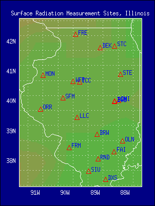
of the ground observing stations are illustrated in Figure A.

Figure A. |
About nineteen
stations are available from the Illinois Climate Network, as provided by the Illinois
State Water Survey, Illinois Department of Natural Resources (Hollinger et al., 1994);
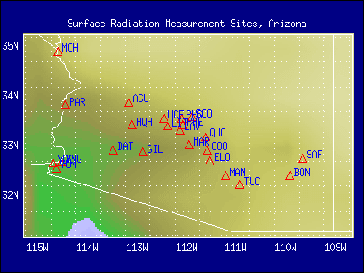
about twenty one stations are available from the Arizona Meteorological Network (AZMET) (Brown, 1989); and four stations from the
Surface Radiation (SURFRAD)
network (Hicks et al., 1995). These include stations in Bondville, Ill., Fort Peck,
Montana, Goodwin Creek, Missouri, and Table Mountain, Colorado.
Several locations have multiple sites. For instance, at Bondville, Ill, both the Illinois
State Water Survey and SURFRAD have independent stations. While most of the stations
observe only downwelling shortwave radiation and provide information at hourly time
intervals, the SURFRAD network is of highest possible quality, the observations are
averaged at three minute intervals, and several components of the surface shortwave
radiative fluxes are available.
Validation Results
The Illinois network is shown in Figure B.
Preliminary results from a comparison between the satellite derived SW fluxes and measurements from six sites
of the Illinois network on daily time scale for May 1996, are presented in Figure 1, and from all nineteen stations on
hourly (a) and daily (b) time scales for June 1997, are presented in Figure 2.
As evident from Figure 1, the RMS of the daily values for the six stations
for the month of May 1996 is in the range of 20-32 Wm-2, and the bias is
quite small. Similar results on daily time scale, are obtained when all the
values is around 100 Wm-2 (Figure 2).
Evaluation of the monthly mean hourly SW fluxes against ground observations for
18 stations in Illinois during July and December 1998 is illustrated in Figure 3, Figure 4,
Figure 5, Figure 6, Figure 7, and Figure 8.
It should be noted that at this
stage, neither the ground truth nor the satellite data were subjected to
quality control. Daily values from the satellite algorithm were computed as
long as more than four satellite observations per day were available. The
interpolation techniques used are described in the "Data Access" section.

Figure B. |

Figure C.
|
The Arizona network is illustrated in Figure C. Results from the
Arizona network of twenty one stations on a monthly time scale for nine months during 1995
and 1996, are presented in Figure 9.
The RMS for the monthly values is only 13 Wm-2, and the correlation coeffient is over 0.97.
In Figure 10,
the frequency distributions of ground observed and satellite
estimated hourly values of SW surface fluxes, as well as the
differences between the two sources of information, are
presented for January-November, 1996, for the Arizona network . It
seems that for the lower values of radiative fluxes, the satellite
estimates tend to exceed the ground observation, while for the
higher value of these fluxes, the ground observations tend to be
higher. There seems to be no difference in the frequency
distribution of the two, for intermediate value of the fluxes.
The location of the SURFRAD stations is illustrated in Figure A. Results from
comparisons between the satellite estimated SW fluxes and measurements from the four
SURFRAD sites on a daily time scale for May 1996, are presented in Figure 11. Results for PAR on monthly time
scale for May 1996, are presented in Figure 12.
The range of the RMS errors at these locations is
similar to what was obtained from the state networks.
While most of the stations observe only downwelling SW radiation at hourly time
intervals, at the SURFRAD locations, observations are averaged at three minute intervals,
and several components of the surface shortwave radiative fluxes are available.
Experiments were performed with different averaging time periods and different spatial
integrations. In Figure 13, a comparison
between satellite estimates and ground observations made at the SURFRAD Bondville, Ill
station were made for May 1996, at four different temporal resolutions. Such experiments
will continue till the best approach to the "coupling" problem is identified.
Based on results of evaluation against ground truth as available from the larger state
networks, it was found that the range of the RMS errors on an hourly time scale was 20-100 Wm-2;
on a daily time scale, it was 20-30 Wm-2; and on a monthly time scale, it was 12-18
Wm-2. Similar studies will be conducted with data from the SURFRAD network.
In the validation process, to "match" the satellite instantaneous view with the hourly time averaged
ground truth the satellite estimates were normalized to the one-hour average value of the
solar zenith angle, namely, the satellite estimated flux was first divided by the solar
zenith angle corresponding to the satellite observations, and then multiplied by the
one-hour average of the solar zenith angle, calculated for the ground location. The
satellite estimates used represent values obtained from the experimental runs, without
adjustments for satellite sensor degradation and without "tuning" to local
conditions. During the winter months, difficulties were encountered with the reported snow
amounts. This led to errors in cloud estimates and related surface fluxes. An effort is
underway at NOAA/NESDIS to remove such problems. A validation activity over snow covered regions is
planned, using special data sets, that include documentation of the snow
conditions.
Not all the parameters available under this project are provided at this
Web site. Additional information will be added after the preliminary evaluation
is completed. An example of a candidate parameter considered for possible
future distribution is a cloud product, as illustrated in Figure
14. Monthly mean cloud cover (%) for January 1998 is presented in Figure 14(a), while a daily mean cloud cover (%)
is given in Figure 14(b).
References
Brown, P., 1989. Accessing the Arizona Meteorological Network by Computer. The
University of Arizona, College of Agriculture, Tucson, AZ 85721.
Hicks, B. B, J. J. DeLuisi, J. A. Augustine, and D. Matt, 1995: The NOAA Integrated
Surface Irradiance Study (ISIS): A New Surface Radiation Monitoring Network. Abstract,
A.G.U. Fall Meeting, December, 1995, San Francisco, CA.
Hollinger, S. E., B. C. Reinke, and R. A. Peppler, 1994. Illinois Climate Network: Site
Description, Instrumentation, and Data Management. Illinois State Water Survey Circular
178. WARM Network Publication 1, 63 pp.
|
